


Happy New Year
January 2, 2019
Mindfulness, philosophers, Positive Thinking, Spiritual Enlightenment, Stoicism peter singhateh, Peter Singhatey 4 Comments
Where Is Your Highest Risk Point For Stall-Spin Accidents
December 12, 2018
Aviation, Flying, Just love flying Aviation, Flying, Just love flying, Madox Air Sports, peter singhateh, Peter Singhatey 1 Comment
Source: Where Is Your Highest Risk Point For Stall-Spin Accidents? | Boldmethod
Where Is Your Highest Risk Point For Stall-Spin Accidents? By Colin Cutler

Nobody thinks it will happen to them. But before you know it, there you are. Low, slow, and approaching a stall.And how well you react in those few seconds makes all the difference in the world. Often times, it’s the difference between a safe recovery and a fatal crash.
Where Do Stall-Spin Accidents Happen The Most?
The Air Safety Foundation conducted a study of 450 stall-spin accidents from 1993 to 2001 to see where they happened, and how they compared to other types of accidents. And to keep the focus on GA, they only looked at accidents where aircraft weighed less than 12,500 pounds.So where did the accidents happen? At least 80% of them started from an altitude of less than 1000′ AGL.What’s the significance of 1000′ AGL? It’s the traffic pattern altitude at most airports.

That brings up the major problem with stall-spin accidents down low. The altitude loss in a stall recovery for most GA aircraft is estimated to be 100-350 feet. Which, in many cases, gives you enough room to recover from a stall in the pattern.But spins are a whole different animal. In the 1970s, NASA studied altitude loss in spins of several aircraft, one of which was the Piper Arrow.What they found was eye-opening. The Arrow had an average loss of 1,160′ in spin entry through recovery. And, keep in mind, that’s in an aircraft flown by a test pilot.
![]()
It doesn’t take a math genius to figure out the problem here. If you’re flying a 1,000′ AGL traffic pattern and you get yourself into a spin, you’re not going to have enough altitude to recover, no matter how quick your reaction, or your recovery technique…
Staying Alert, Especially Down Low
This, like most things in aviation, always comes back to the basics.There’s no substitute for flight proficiency. And when things start to fall apart in the pattern, going around and giving yourself another chance is almost always the best option.So the next time you’re flying, climb up to altitude and practice some stalls and slow flight. And if it’s been a long time since you’ve done either, grab an instructor so they can give you feedback on how you did.A little practice and proficiency can go a long way. And it can keep you reading about accident studies like this, instead of becoming one of the NTSB’s statistics.
Become a better pilot. Many thanks to Boldmethod for sharing…
5 Rules of Thumb Every Pilot Should Know Boldmethod
November 22, 2018
Aviation, Flying, Microlight Aircraft Flying, Just love flying, peter singhateh, Peter Singhatey, Pilot, Positive Thinking Leave a comment
Source: 5 Rules-of-Thumb Every Pilot Should Know | Boldmethod
5 Rules of Thumb Every Pilot Should Know Colin Cutler
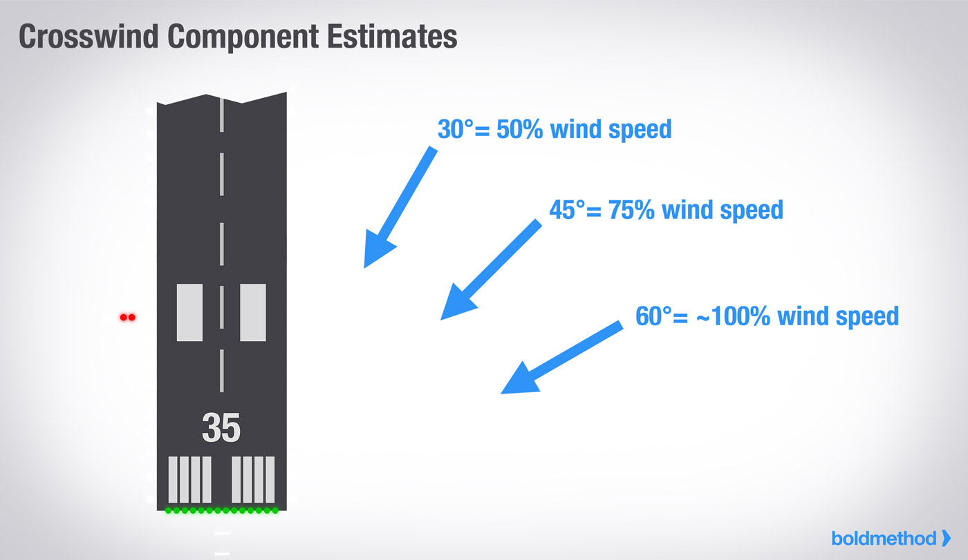
1) Estimating Your Crosswind Component
When you’re on the ground, it’s easy to use the crosswind chart in your POH, or an E6B. But when you’re in the air, neither of those options are very practical.
Lucky of all of us, there’s an easier way. If the wind is 30 degrees off the runway, your crosswind component is about 50% of the wind speed.
If the wind is 45 degrees off the runway, the crosswind component is about 75% of the wind speed.
And if the wind is 60 degrees or more off the runway, the crosswind component is roughly the same as the total wind.
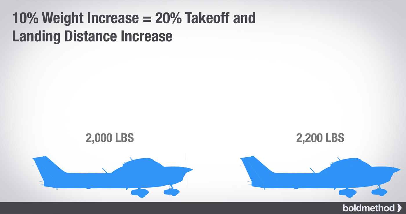
2) 10% Weight Increase = 20% Takeoff and Landing Distance Increase
The more weight you have, the more runway you need. And while this rule is far from exact, it gets you in the ball park for a normally aspirated plane.
Obviously, when it comes time to calculate your actual performance, you’ll want to pull out your POH.
3) Takeoff roll increases about 10% for every additional 1,000 feet of density altitude
For most normally-aspirated airplanes, you add about 10% of takeoff roll distance for every 1,000′ of density altitude (DA).
For example, in Denver, with an increase of 3,200′ of density altitude, you’d increase your takeoff roll by about 32%.
So if you have a 1,500′ takeoff roll on a standard day in Denver (3 degrees C), you’ll increase that roll to almost 2,000′ on a 30C day.

4) When Should You Start Your Descent?
3 degrees is a comfortable descent rate in just about any aircraft. But when you’re approaching an airport, how do you know when to start down?
Divide the altitude you need to lose by 300.
For example, if you’re at 11,000′, and you need to get down to a pattern altitude of 2,000′, you need to descend 9,000′.
9,000/300 = 30 miles.
If you start a 3-degree descent 30 miles out, you’ll hit pattern altitude as you reach the airport. Keep in mind, you’ll want to add a few miles on to your number, so you hit pattern altitude slightly before you get to the airport.

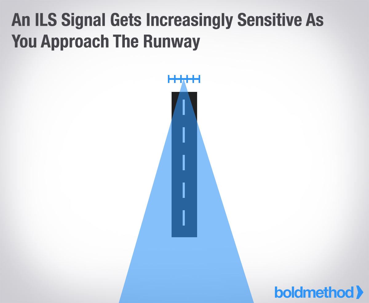
5) ILS Course Width
VFR pilots can make good use of the ILS too. Whether it’s a dark moonless night, or a long straight-in on a hazy day, following the ILS to your runway keeps you safe from terrain and obstructions (not to mention, you know you’re lined up with the right runway).
The closer you get to the runway, the more sensitive the signal is. As you cross the threshold, 1/2 dot deflection on the localizer = about 1/2 the runway width. So if you’re a half dot off as you approach the runway, you’re going to be looking at the runway edge lights.
What are other rules-of-thumb do you use? Tell us in the comments below.
September 30, 2018
Aviation, Flying, Just love flying Flying, Just love flying, peter singhateh, Peter Singhatey, PeterSinghateh 1 Comment

Brilliant Pictures…
September 30, 2018
Aviation, Flying, Just love flying Flying, Just love flying, peter singhateh, Peter Singhatey, PeterSinghateh 1 Comment

Just a Brilliant Picture…
Red Admiral butterfly in August
August 24, 2018
Be inspired, Mindfulness, Nature, Uncategorized Great Pictures, peter singhateh, Peter Singhatey 6 Comments
Lovely pictures. Many thanks for sharing
I just love the colors of this Red Admiral butterfly (Vanessa atalanta) that I photographed on Monday at Occoquan Bay National Wildlife Refuge. I mean, really, how can you not like an insect that sports the red, white, and blue?
You don’t have to be American to like those three colors—it seems like there are an awful lot of countries that use them in various shades and patterns in their national flags.

© Michael Q. Powell. All rights reserved
Birding in and around Windhoek Nature Travel Birding
August 10, 2018
Birds, Flying, Nature, Uncategorized peter singhateh, Peter Singhatey 2 Comments


Many people find it strange that I love my hometown of Windhoek so much. They say it is dry and drab, but I see it completely differently. It sits at 1700 metres above sea level (12th highest capital in the world) in the Khomas Highland plateau area between the Auas and Eros mountain ranges. It […]


You must be logged in to post a comment.